Travel/POI: Yosemite National Park (優勝美地/約塞米蒂國家公園), California - Mirror Lake, Pioneer Yosemite History Center, Washburn Point, Glacier Point, Yosemite Village, Olmsted Point, Tenaya Lake
Yosemite National Park Introduction Post
Mirror Lake 鏡湖
Mirror Lake is a small, seasonal lake located on Tenaya Creek in Yosemite National Park. It lies directly between North Dome and Half Dome and is famous for its reflections of Half Dome and Mount Watkins. Mirror Lake has little water for much of the year, and it is fullest in spring and early summer, when Tenaya Creek flows freely with fresh snowmelt.
In late summer, due to the lack of water and the influx of grasses and sandy areas, Mirror Lake is often referred to as Mirror Meadow.
In both 2017 and 2023, we parked at Curry Village (called Half Dome Village in 2017), then walked about two miles along the Mirror Lake Trail from there. Curry Village is a resort offering standard hotel rooms, wooden cabins, and canvas tent cabin accommodations. In 1899, David A. Curry and Jenny Etta Foster (later known as Mother Curry) opened a tented camp. It was developed in the early 20th century as a camp concession for park tourists.
See the official website for more information about the accommodations and activities available in the Curry Village area.
In May 2017, Tenaya Creek had abundant water, and the scenery at Mirror Lake was very beautiful. In 2024, after reading reviews that mentioned Mirror Lake had dried up, we decided not to visit.
鏡湖是位於優勝美地國家公園特納亞溪 (Tenaya Creek) 上的小型季節性湖泊。它位於北穹頂 (North Dome) 和半穹頂 (Half Dome) 之間,以半穹頂和沃特金斯山 (Mount Watkins) 的倒影而聞名。鏡湖一年中大部分時間水量稀少,春季和初夏時最為充沛,此時特納亞溪匯入剛融化的雪水,水流奔騰。
夏末,由於缺水以及草叢和沙地的匯集,鏡湖通常被稱為鏡湖草甸。
2017 年和 2023 年,我們都把車停在庫里村 (Curry Village) (2017 年稱為半圓頂村 Half Dome Village),然後沿著鏡湖步道步行約兩英里。庫里村是一個度假村,提供標準飯店客房、木屋和帆布帳篷小屋。 1899 年,大衛·庫里和珍妮·福斯特(後來被稱為“庫裡媽媽”)開設了一個帳篷營地。它是在 20 世紀初發展起來的,最初是為公園遊客提供的營地特許專營區。
有關克里村地區住宿和活動的資訊,請到官方網站查詢。
2017 年 5 月,特納亞溪水量充足,鏡湖景色也特別美。 2024 年,看到評論說鏡湖已經乾涸,我們決定不去鏡湖。
On the way to Mirror Lake 去鏡湖的途中


Mirror Lake 鏡湖


On the way to Mirror Lake 去鏡湖的途中


Mirror Lake 鏡湖


Pioneer Yosemite History Center 優勝美地先驅歷史中心
Before we went to Glacier Point in 2017, we first stopped by the Pioneer Yosemite History Center. Located in Wawona, it is a collection of historic buildings assembled from various parts of Yosemite National Park. In the summer, the center also offers special programs and carriage rides.
2017 年,在去冰川頂 (Glacier Point) 之前,我們先去了優勝美地先驅歷史中心。它位於瓦沃納,匯集了優勝美地國家公園各個地方的歷史建築。夏季,中心也會舉辦特別活動和坐馬車的行程。


Washburn Point 沃什伯恩角
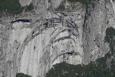
Washburn Point is located along Glacier Point Road, near Glacier Point. This overlook provides stunning views of Half Dome and the eastern crest of the Sierra Nevada. From this vantage point, visitors can also see the "giant staircase" waterfalls—Nevada Fall and Vernal Fall—as well as Illilouette Fall.
Vernal Fall is a 317-foot waterfall on the Merced River, just downstream from Nevada Fall, which drops 594 feet. Illilouette Fall is a 381-foot waterfall on Illilouette Creek, a tributary of the Merced River.
Washburn Point is named after the Washburn brothers, who built the first road from Wawona to Yosemite Valley.
沃什伯恩角位於冰川頂路沿線,靠近冰川頂。從這裡可以俯瞰半穹頂和內華達山脈東麓的壯麗景色。從這裡,遊客還可以欣賞到「巨型階梯」瀑布——內華達瀑布 (Nevada Fall) 和弗納爾瀑布 (Vernal Fall)——以及伊利洛埃特瀑布 (Illilouette Fall)。
弗納爾瀑布是默塞德河 (Merced River) 上一座落差 317 英尺(約 91 公尺)的瀑布,位於內華達瀑布下游,後者落差 594 英尺(約 180 公尺)。伊利路埃特瀑布是默塞德河支流伊利路埃特溪(Illilouette Creek)上一座落差 381 英尺(約 116 公尺)的瀑布。
沃什伯恩角以沃什伯恩兄弟的名字命名,他們建造了第一條從瓦沃納到優勝美地山谷的道路。


Glacier Point 冰川頂
Glacier Point, at an elevation of 7,214 feet, is a viewpoint overlooking Yosemite Valley, Half Dome, Yosemite Falls, and the Yosemite high country. It can be reached from the valley via Glacier Point Road, which is typically open from late May through October or November. In winter, Glacier Point Road is closed due to snow, and access to Glacier Point from the Badger Pass Ski Area is only possible by skiing or snowshoeing for 10.5 miles.
冰川頂海拔 7,214 英尺 (約 2199 公尺),是俯瞰優勝美地山谷、半穹頂、優勝美地瀑布和優勝美地高地的觀景點。從山谷出發,可經由冰川頂路前往,此路通常於五月下旬至十月或十一月開放。冬季,冰川頂路會因積雪而關閉,從 Badger Pass 滑雪場前往冰川頂只能透過滑雪或穿雪鞋行走 10.5 英里 (約 16.9 公里)。


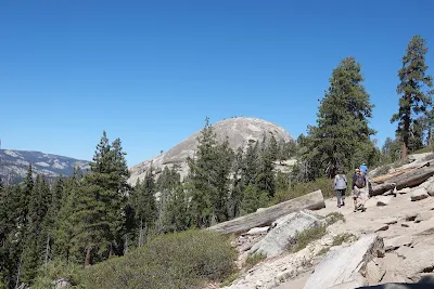
Sentinel Dome and Taft Point 哨兵穹頂和塔夫脫角
Sentinel Dome and Taft Point share the same trailhead along Glacier Point Road. They can be hiked separately or combined as a loop trail. The Taft Point hike by itself is a 2.2-mile round trip with a 350-foot elevation gain. The Sentinel Dome hike by itself is also a 2.2-mile round trip, with a 450-foot elevation gain. I only hiked halfway up the Sentinel Dome trail.
哨兵穹頂和塔夫脫角位於冰川頂路的同一條步道起點。它們可以各自單獨健行,也可以合併兩段成一條環形步道。塔夫脫角健行路線本身往返全長 2.2 英里 (3.54 公里),海拔增益 350 英尺 (107 公尺)。哨兵穹頂健行路線本身往返全長 2.2 英里,海拔增益 450 英尺 (137 公尺)。我只在哨兵圓頂健行步道走了一半。

Wawona Hotel 瓦沃納酒店
One of California’s original mountain resort hotels, the Victorian-era Wawona Hotel was originally established in 1856. Accommodations include 50 standard hotel rooms with private baths and 54 standard rooms with shared restrooms. The hotel dining room serves breakfast, lunch, and dinner.
維多利亞時代的瓦沃納酒店始建於 1856 年,是加州最早的山間度假酒店之一。飯店設有 50 間附獨立衛浴的標準客房和 54 間附共用衛浴的標準客房。飯店餐廳供應早餐、午餐和晚餐。


Yosemite Village Historic District 優勝美地村歷史街區
The Yosemite Village Historic District includes visitor service areas, park personnel residences, and administrative facilities. It is located north of the Merced River and was added to the National Register of Historic Places in 1978.
The most significant building in the historic district is the Rangers’ Club, built in 1924 to house rangers. Early residences used wood shingles and natural materials, and were rustic in character.
The Park Superintendent’s Residence was built in 1912 by the U.S. Army and was extensively remodeled in the 1920s to meet National Park Service rustic design standards.
Non-residential buildings include the Administration Building (1924), the Post Office (1925), and the Museum Building (also known as the Valley District Building) completed in 1926. All are rustic in character.
Other notable buildings in the area include the Pohono Indian Studio (1925), now used as a gift shop, and the Ansel Adams Gallery, a complex of five buildings originally known as Best's Studio.
優勝美地村歷史街區包括遊客服務區、公園工作人員住宅和行政設施。它位於默塞德河以北,於 1978 年被列入國家史蹟名錄。
歷史街區中最重要的建築是國家公園管理員俱樂部,它建於1924年,供國家公園管理員居住。早期的住宅使用木瓦和天然材料,具有質樸的鄉村風格。
公園管理員官邸由美國陸軍於 1912 年建造,並於 1920 年代進行了大規模改建,以符合國家公園管理局的質樸鄉村設計標準。
非住宅建築包括行政建築(1924 年)、郵局(1925 年)和博物館建築(也稱為山谷區建築),於 1926 年竣工。所有建築都有鄉村風格。
該地區其他著名建築包括波霍諾印第安人工作室 (Pohono Indian Studio)(1925 年),現用作禮品店,以及安塞爾·亞當斯藝術博物館 (Ansel Adams Gallery),這是一座由五座建築組成的建築群,最初被稱為最出色的工作室。


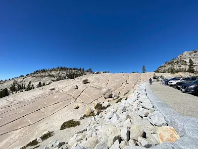
Olmsted Point 奧姆斯特德點
Olmsted Point is a viewing area off Tioga Pass Road that offers a view south into Tenaya Canyon. This vista is famous for its view of the northern side of Half Dome, Clouds Rest, and Tenaya Lake to the east. Olmsted Point was named after the famed landscape architects Frederick Law Olmsted (best known for designing New York’s Central Park) and his son, Frederick Law Olmsted Jr.
奧姆斯特德點是第奥嘉隘口公路旁的觀景點,可向南眺望特納亞峽谷 (Tenaya Canyon) 。該觀景點以其北側的半穹頂、雲憩山莊和東側的特納亞湖的景色而聞名。奧姆斯特德點以著名景觀設計師弗雷德里克·奧姆斯特德(以設計紐約中央公園而聞名)及其兒子小弗雷德里克·奧姆斯特德的名字命名。


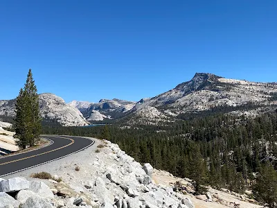

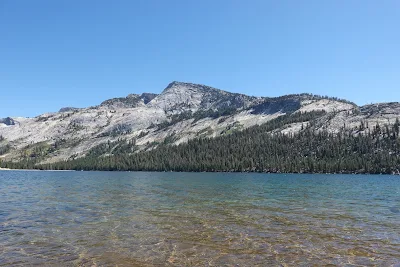
Tenaya Lake 特納亞湖
Tenaya Lake is an alpine lake located between Yosemite Valley and Tuolumne Meadows. The surface of Tenaya Lake sits at an elevation of 8,150 feet (2,484 meters). It is the largest lake in Yosemite's frontcountry. Hiking, fishing, and water activities such as kayaking, canoeing, and sailing are popular here.
Tenaya Lake is named after Chief Tenaya, the leader of the Indigenous people who lived in Yosemite Valley before being driven out by the Mariposa Battalion. Chief Tenaya protested that the lake already had a name: Pie-we-ack, or "Lake of the Shining Rocks." That original name is now attached to Pywiack Dome, a granite dome located to the east of the lake.
特納亞湖是位於約塞米蒂山谷和圖奧勒米草甸之間的高山湖泊。特納亞湖水面海拔 8,150 英尺(2,484 公尺)。它是約塞米蒂前緣最大的湖泊。健行、釣魚以及划橡皮艇、獨木舟和帆船等水上活動在這裡都很受歡迎。
特納亞湖以特納亞酋長的名字命名,他是優勝美地山谷原住民的領袖,後來被馬里波薩營驅逐。特納亞酋長抗議說,這個湖已經有了一個:Pie-we-ack,意為「閃亮岩石之湖」。這個名字現在與位於湖東側的花崗岩穹頂 Pywiack Dome 連在一起。


References 參考資料
- National Park Service: Mirror Lake Trail
- National Park Service: Washburn Point
- Wikipedia: Glacier Point
- National Park Service: Wawona Hotel
- Serena's Lenses: Taft Point and Sentinel Dome Loop Hike in Yosemite National Park
- Wikipedia: Yosemite Village Historic District
Other Related Posts 其他相關的帖子
- Travel/POI: Sequoia National Park (紅杉國家公園), California - Tunnel Rock, Hospital Rock, Moro Rock Trail
- Travel/POI: Sequoia National Park (紅杉國家公園), California - Tunnel Log, Big Trees Trail, Giant Forest Museum, General Sherman Tree
- Travel/POI: Kings Canyon National Park (國王峽谷國家公園), California - Grizzly Falls, Roaring River Falls, General Grant Tree Trail
- Travel/POI: Yosemite National Park (優勝美地/約塞米蒂國家公園), California - Tunnel View, Bridalveil Fall, El Capitan, Middle Cathedral Rock, Sentinel/Cook's Meadow Loop, Yosemite Falls, Half Dome
Travel/Point of Interest Posts 旅遊景點帖子