Travel/POI: Sequoia National Park (紅杉國家公園), California - Tunnel Rock, Hospital Rock, Moro Rock Trail, Hanging Rock
Sequoia National Park is an American national park in California, notable for its giant sequoia trees. The park was established as the nation’s second national park on September 25, 1890, by President Benjamin Harrison. Created to protect the giant sequoia trees from logging, Sequoia National Park was the first national park formed to protect a living organism: Sequoiadendron giganteum.
I’m very curious about why the entrance sign to Sequoia National Park features a Native American image. If you’re interested in learning the answer, you can read this article about Sequoia's Historic Park Entrance Sign.
We have visited Sequoia National Park four times—in 2017, 2019, 2023, and 2024—and I’ll be using a mix of photos from those years in this post.
Please note that the Generals Highway is closed to public travel between the parks from January 1 to mid-March, and it may also close due to storms. Be sure to check the NPS website before planning your trip.
We entered the park through its southern entrance near the town of Three Rivers at Ash Mountain in 2017, 2023, and 2024. Our first stop was the Foothills Visitor Center.
紅杉國家公園是位於加州的美國國家公園,以巨大的紅杉樹而聞名。1890 年 9 月 25 日由本傑明·哈里森總統建立公園,成為美國第二個國家公園。紅杉國家公園是為了保護巨杉樹免於砍伐而創建的,是第一個為保護生物(巨杉)而建立的國家公園。
我很好奇為什麼紅杉國家公園的入口標示是用個美州原住民的頭像,有興趣想知道答案,可以看看這篇[紅杉歷史公園入口標誌]的文章。
我們來這裏造訪過四次,2017,2019, 2023 及 2024. 我將在這篇文章中混合使用這四年的照片。
請注意,1 月 1 日至 3 月中旬,將軍 (Generals) 高速公路會關閉公園之間的公共交通,它也可能因暴風雨而關閉,所以在規劃您的旅程之前,請先查看國家公園網站。
2017 年和 2023 年,我們從灰山 (Ash Mountain) 三河鎮附近的南入口進入公園。我們先去了山麓 (Foothills) 遊客中心。


Park Map 公園地圖
Click here for Interactive Park Map from NPS

Foothills Visitor Center 山麓遊客中心


Tunnel Rock 隧道岩
After passing the Foothills Visitor Center and driving along the Generals Highway, we arrived at the next viewing point: Tunnel Rock. This granite boulder once created a tunnel over the Generals Highway until the road was rerouted. Cars can no longer drive under it.
過了山麓遊客中心後,沿著將軍公路行駛,我們到達了下一個觀景點隧道岩 (Tunnel Rock)。隧道岩這塊花崗岩巨石,在將軍公路上形成了一條通道,直到道路改道,汽車現在不能再在它下面行駛穿過。


Hospital Rock 醫院岩
The next stop is Hospital Rock. This spot along the Kaweah River supports a diverse mix of animals, plants, and trees. The richness of this landscape made it an ideal location for Pah-din, meaning “a place to go through,” a village that was home to 500 Potwisha Native Americans. Several large granite boulders at this site provided temporary shelter or space for tribal gatherings. Archaeological evidence shows settlement as early as 1350, and bedrock mortar sites and pictographs remain.
In 1860, John Swanson, the brother-in-law of pioneer Hale Tharp, sustained an injury to his leg and was transported here, where local Indians treated the injury. Hale Tharp later gave the spot its name after a second similar incident. The English name “Hospital Rock” was first used in 1873, after James Everton recovered from a gunshot wound at the site. Today, Hospital Rock is a public archaeological site with a picnic area and a short trail that leads to a nearby waterfall.
下一站是醫院岩。卡威河 (Kaweah River) 沿岸的醫院岩地區生長著多種動物、植物和樹木。富饒的田野使其成為 Pah-din 的理想所在地,原住民語言的 Pah-din 是「要經過的地方」的意思,這個村莊居住著 500 名 Potwisha 美洲原住民。在這個地方,幾塊巨大的花崗岩巨石為部落聚會提供了臨時庇護所/空間。考古證據顯示早在 1350 年就有人定居在此,基岩研缽遺址和象形文字仍然存在。
1860 年拓荒者黑爾·薩普 (Hale Tharp) 的妹夫約翰·斯旺森 (John Swanson) 腿部受傷,被送往給當地的印第安人接受治療。在發生第二次類似事件後,黑爾·薩普給了這個地方這個名字。英文名稱「醫院岩」於 1873 年首次使用,因為當時詹姆斯埃弗頓 (James Everton) 在此從槍傷中康復。現在醫院岩已成為公共的考古遺址,設有野餐區和一條通往附近瀑布的短步道。


Moro Rock 摩洛岩
Moro Rock, a dome-shaped granite monolith, is located in the center of the park at the head of Moro Creek, between Giant Forest and Crescent Meadow. The name "Moro Rock" derives from the blue roan mustang color that Mexicans call moro, owned by a Mr. Swanson of Three Rivers in the 1860s. Because of its prominence, with a peak elevation of 6,720 feet, Moro Rock can be seen from many spots in the park.
摩洛岩是一塊圓頂形花崗岩巨石,位於公園中心、在摩洛溪源頭、也就是在巨型森林 (Giant Forest) 和新月草甸 (Crescent Meadow) 之間。「摩洛岩」這個名字來自一匹藍色花毛的野馬 (墨西哥人稱之為摩洛),它是 1860 年代三河 (Three Rivers) 的斯旺森 (Swanson) 先生所擁有的。由於摩洛岩的山峰高達 6,720 英尺,因此在公園的許多地方都可以看到它。


Amphitheater Point 露天劇場點
The next stop, Amphitheater Point, at 4,390 feet, is located between the Hospital Rock Picnic Area and the Giant Forest Museum. This viewpoint offers stunning views of Moro Rock and the steep elevation change from the foothills to the granite peaks.
下一站露天劇場點 (Amphitheatre Point) 海拔 4,390 英尺,位於醫院岩野餐區和巨型森林博物館之間。從這個觀景點可以欣賞摩洛岩的壯麗景色以及從山麓到花崗岩山峰的陡峭海拔變化。


Hanging Rock trail 懸岩步道
Hanging Rock trail is a 0.3-mile out-and-back trail near Moro Rock. It is generally considered a moderately challenging route—steep but not difficult. The trail offers scenic views of the Kaweah River Valley as well as a side view of Moro Rock.
懸岩步道 (Hanging Rock Trail) 是一條靠近摩洛岩步道 (Moro Rock Trail) 來回 0.3 英里長的步道。它通常被認為是一條中等挑戰性的路線,雖然陡峭但並不困難。在此可俯瞰卡威河谷(Kaweah River Valley)的美麗風景,以及從側面欣賞摩洛岩的景色。


Moro Rock Trail 摩洛岩步道
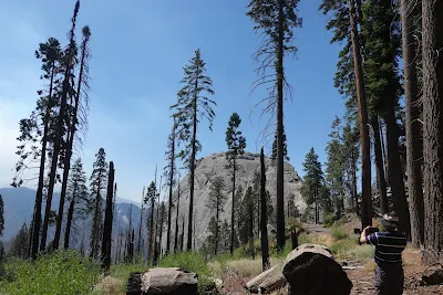
Then we came to Moro Rock Trail. This 0.5-mile out-and-back trail, with a 183-foot elevation gain, is worth exploring. The summit of Moro Rock offers some of the greatest views of the southern Sierra. From the top, you can see the Great Western Divide peaks, the San Joaquin Valley, and the wilderness of Sequoia National Park.
The rock was first climbed by pioneer cattleman Hale Tharp and his family in the 1860s, who found reaching the top a difficult scramble. After the Giant Forest became part of Sequoia National Park in 1890, Moro Rock gained attention as a tourist destination. By 1903, the soldiers who looked after the park had built a wagon road allowing visitors to reach the northern base of the rock. Ascending the rock, however, still required a risky scramble.
Finally, in 1917, a set of wooden steps was built up the narrow ridge leading to the summit. This stairway deteriorated significantly by the late 1920s and was replaced in 1931 by the present Moro Rock Stairway, constructed by the Civilian Conservation Corps. Unlike the earlier stairway, the new design aimed to blend with the natural surfaces as much as possible.
The 797-foot-long stairway was designed by National Park Service landscape architect Merel S. Sager and engineer John Diehl, following natural ledges and crevices. It has 400 steps leading to the summit of Moro Rock. In 1978, in recognition of its exceptional design, the Moro Rock Stairway was added to the National Register of Historic Places as an example of rustic design by the National Park Service.
Today (2023), more than ninety years later, Moro Rock remains one of the best-loved features of Sequoia National Park. During summer, free shuttles run to this trailhead. On summer weekends, the road closes to private vehicles, so you'll need to take the shuttle to reach the trailhead. In winter, ski trails lead to the Moro Rock parking area, but the staircase itself is closed due to hazardous conditions.
For more information on shuttles, please visit: Park Shuttles.
然後我們來到了摩洛岩步道。這條來回 0.5 英里有著 183 英尺的海拔增益路線是值得造訪的。摩洛岩的頂峰是南部鋸齒山脊(Sierra)的絕佳景觀之一。從山頂可看到大西分水嶺(Great Western Divide)山峰 、聖華金(San Joaquin)河谷和紅杉國家公園荒無人煙的地區。
1860 年代拓荒者牧牛人黑爾·薩普(Hale Tharp)及其家人首次攀登這塊岩石,他們發現登頂很困難。1890 年巨型森林成為紅杉國家公園的一部分後,這塊岩石倍受關注,因為它成為旅遊之地。到 1903 年,早期看守公園的士兵建造了一條馬車路,讓遊客可以到達岩石的北部底部,然而攀登岩石仍是冒險之舉。
最後在 1917 年在通往山頂的狹窄山脊上建造了一組木台階,但這木樓梯在 1920 年代末期嚴重損壞,於 1931 年被平民保育團 (Civilian Conservation Corps) 所建造現今的摩洛岩石樓梯取代,與之前的樓梯不同的是新樓梯採取了與自然最大融合的設計策略。
這條 797 英尺長的樓梯由國家公園管理局景觀設計師 Merel S. Sager 和工程師 John Diehl 沿著自然壁架和裂縫設計,共有近 400 級階梯通往摩洛岩頂峰。1978 年為了表彰其優秀的設計,國家公園管理局的摩洛岩石階梯被加入到國家歷史名勝名錄中,作為質樸設計的典範。
九十多年後的今天 (2023),摩洛岩仍然是紅杉國家公園最受歡迎的景點之一。夏季期間有免費接駁車開到步道起點。夏季週末道路禁止私家車通行,因此您必須搭乘接駁車到步道起點。冬季有滑雪道到摩洛岩停車場,但樓梯本身因危險而關閉。
有關接駁車的更多信息,請查看:接駁車


Flashback 回顧
On June 8, 2019, we first visited Kings Canyon National Park next door and then went to Sequoia National Park, where we saw a different entrance sign.
2019 年 6 月 8 日我們先去了隔壁的國王峽谷國家公園,再到紅杉國家公園,所以看到的入口標置也不同。


Other Related Posts 其他相關的帖子
- Travel/POI: Sequoia National Park (紅杉國家公園), California - Tunnel Log, Big Trees Trail, Giant Forest Museum, General Sherman Tree
- Travel/POI: Kings Canyon National Park (國王峽谷國家公園), California - Grizzly Falls, Roaring River Falls, General Grant Tree Trail
- Travel/POI: Yosemite National Park (優勝美地/約塞米蒂國家公園), California - Tunnel View, Bridalveil Fall, El Capitan, Middle Cathedral Rock, Sentinel/Cook's Meadow Loop, Yosemite Falls, Half Dome
- Travel/POI: Yosemite National Park (優勝美地/約塞米蒂國家公園), California - Mirror Lake, Pioneer Yosemite History Center, Washburn Point, Glacier Point
Travel/Point of Interest Posts 旅遊景點帖子
References 參考資料
- National Parks Service: Sequoia and Kings Canyon National Park
- Wikipedia: Sequoia National Park
- Wikipedia: Hospital Rock (Three Rivers, California)
- Tulare County Treasures: MORO ROCK STAIRWAY